| Roman Coastal State Nature Reserve | The Map

The map


State Nature Reserve of the Roman Coastal Area
1.  The Tower of Palidoro
2.  "Macchiagrande" of Galeria
3.  The LIPU Oasis of  Guido's Castle and the Village
4.  The Mouth of the Arrone (Bocca di Leone)
5.  The Castle of  Maccarese
6.  The Maccarese Ponds
7.  The Spring Tower
8.  The Pinewood of  Fregene
9.  The WWF Oasis of Macchiagrande (italian)
10. The "Coccia di Morto" Estate
11. The Village of Porto
12. Claudius and Trajan's Port - The Roman Ship Museum
13. The "Villa Guglielmi"
14. "Isola Sacra" - Necropolis - St Ippolito Church
15. The river Tiber
16. The Roman Ruins of Ostia Antica
17. The Castle and the Village of  Ostia Antica
18. Reclaiming: water-scooping machine
19. The "Boacciana" Tower
20. St Micheal's Tower and C.H.M
21. The pinewood of "Acque Rosse"
22. "Pianabella Procoio" Estate
23. The Park of Castel Fusano
24. Pond's Canal and the Chigi Castle
25. Castel Fusano - Via Severiana and "Villa di Plinio"
26. Castel Porziano and Capocotta Estates
27. Capocotta and the dunes
28. The Malafede Valley
29. The Dead River (Tiber)


home page - LIPU Roman Coastal Branch This Web Site has been realized by the Lega Italiana Protezione Uccelli (Italian Society for the Protection of Birds) - Roman Coastal Branch. For any information contact us:

Mail Lipu Ostia


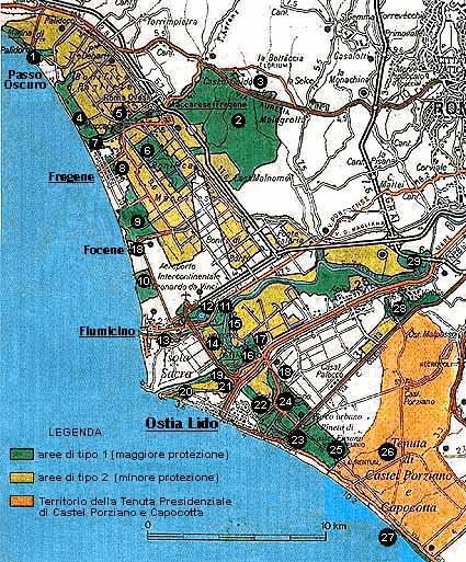
The map of the Roman Coastal State Nature Reserve has been drawn from the publication "La Riserva Naturale Statale del Litorale Romano", realized on ecological paper by the WWF Roman Coastal Branch with the patronage of the Commune of Rome (JANUARY 1997). Then  we have done some modifications to the original Map for making it more complete.

Last update: 11/08/97 09:49:26
Copyright © 5/12/1997: Roberto Trezza